FMIS - Fire Management Information System
Since 1996, I have been involved, first as a contributor and subsequently as the lead engineer, in the development of a decision-support system for the management of forest fires - FMIS.
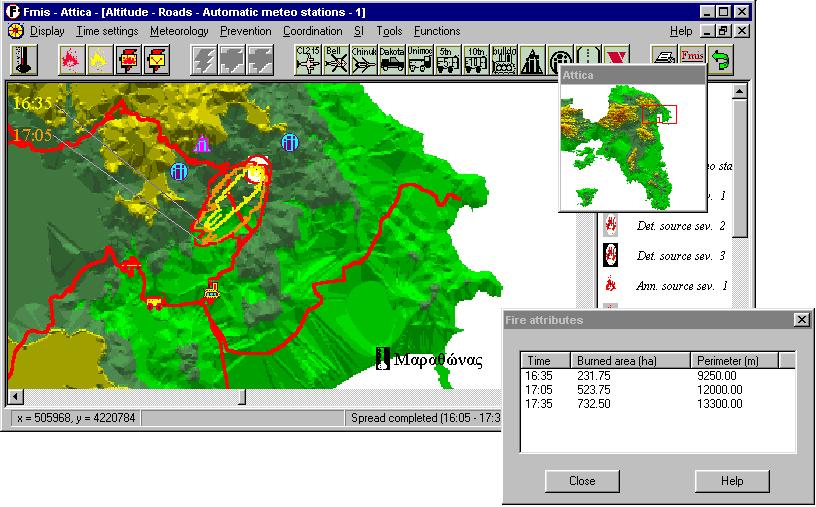
The prime function of FMIS is to simulate and graphically depict the likely spread of a fire on a geographical map, based upon the prevailing meteorological conditions (temperature, wind) as well as the parameters of the vegetation. Other functions include the estimation of danger of a fire outbreak and the distribution of fire-fighting resources in the area.
The system has been built in C++. All work on FMIS was carried out in the context of my employment at Algosystems S.A. and my cooperation with PangaiaSys, both software companies based in Athens, Greece.
The system began life as a desktop application, a screenshot of which is shown below. It was subsequently integrated as a toolbar in the ESRI ArcGIS system and was for some time put to use at the offices of the Fire Brigade of Greece.
For more information on FMIS, you are welcome to read an article, which I wrote for the French journal Bois et Forêts des Tropiques. As lead engineer, I was also responsible for the writing of the documentation and the user manual of the system. I also supervised the translation of its user interface into different languages.
Since 1996, I have been involved, first as a contributor and subsequently as the lead engineer, in the development of a decision-support system for the management of forest fires - FMIS.
The prime function of FMIS is to simulate and graphically depict the likely spread of a fire on a geographical map, based upon the prevailing meteorological conditions (temperature, wind) as well as the parameters of the vegetation. Other functions include the estimation of danger of a fire outbreak and the distribution of fire-fighting resources in the area.
The system has been built in C++. All work on FMIS was carried out in the context of my employment at Algosystems S.A. and my cooperation with PangaiaSys, both software companies based in Athens, Greece.
The system began life as a desktop application, a screenshot of which is shown below. It was subsequently integrated as a toolbar in the ESRI ArcGIS system and was for some time put to use at the offices of the Fire Brigade of Greece.
For more information on FMIS, you are welcome to read an article, which I wrote for the French journal Bois et Forêts des Tropiques. As lead engineer, I was also responsible for the writing of the documentation and the user manual of the system. I also supervised the translation of its user interface into different languages.